My priorities were a bit torn today. There were a number of waterfalls up in the Keweenaw that I wanted to visit, long exploring hikes through wet snow and deep woods that would make a real challenge. But I was tired. Yesterday's adventure up by Cedar Creek had been a tough haul and my legs were sore. It was mid-morning by the time I got out of bed and approaching noon when I finally decided to head out. The least I could do was try to see a few easy drops.
I drove up through Eagle River, craning my head over at the falls as I passed. There was a decent amount of flow here yet not enough to warrant a stop. I have seen pictures of this drop in full force, with gushing white water stretching from bank to bank, and that was not happening today. So it wasn't until I reached Jacob's Creek and the Jampot that I pulled over to the shoulder and parked.

Jacob's Falls
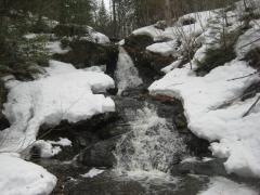
Jacob's Falls was running nicely, a smooth sheet of white covering much of the lower falls. There was more flow than a typical summer run but not so much as to overflow its banks and complicate access. Logan and I scrambled up the snowy side and began to climb further up the creek.
There are plenty of drops above the roadside slide. For a few hundred feet up the side of the Keweenaw ridge the tiny creek plunges and cascades over a rocky bed to form many small and scenic waterfalls. Seeing them involves climbing up the side of the roadside slide and playing around within a narrow canyon, one that is cluttered and can be difficult to follow. Today it was difficult. Slick rock combined with wet snow to keep me on all fours for most of the journey upstream.

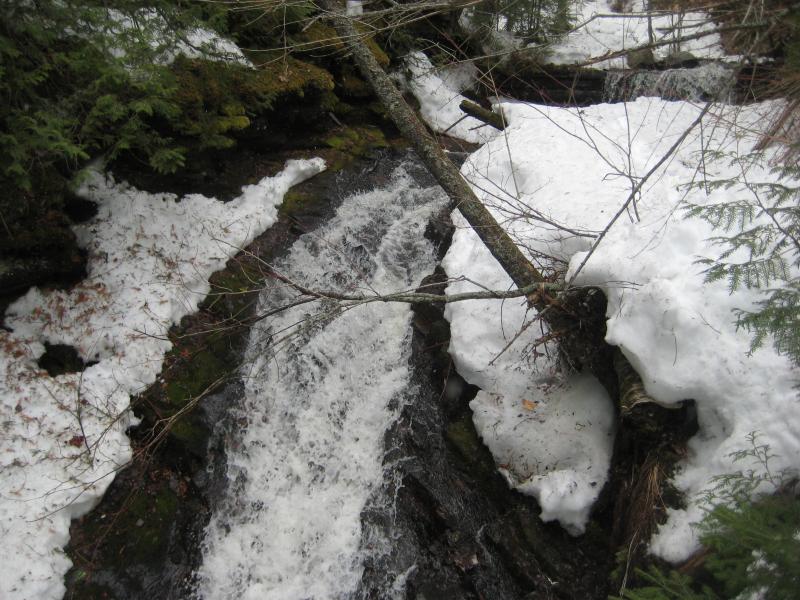
Icy chain of drops with draping logs
When I reached the impassable chute I wasn't too upset about jumping up and out of the little gorge. The creek narrows into crack maybe two feet wide with no banks to speak of and always forces me to climb out. Above the rocky walls was a long bank of needles, and above that was a narrow trail. This trail provides an easy, if less adventurous, path from the road below up along the creek. I had never followed it upstream past this point. It was time to decide how much I wanted to tackle today.

Impassable chute blocking the way

Looking down a needle-covered bank
My ambitious plan was to follow Jacob's Creek up to the cutoff road, the cutoff road east, and then come down Owl Creek past Copper Falls. There were more than a few unknowns. I didn't know if this trail would lead all the way up to the road, how thick the growth around Owl Creek was, or how I would get from the bottom of Owl Creek back to my car. Two miles of swamp separated the two creeks. My legs felt okay so far, and Logan seemed to want to continue, so I decided it was worth a shot. With no exit strategy I turned and headed upstream.
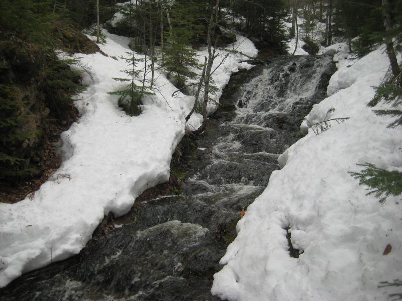
So I was following Jacob's Creek upstream beyond the main falls in search for more drops. While the needle-covered trail made for easy going I wasn't going to see any waterfalls from up here. After a few minutes I attempted to drop back down to the water's edge to see how easy it would be to just follow that. Snow still clustered on both banks and numerous trees blocked the way. This didn't really look like a good option. I headed back up to the trail and tried to be content with the more distant vantage point.

Tight route around the little creek
As I headed south the land climbed and the gorge grew. The creek didn't appear to change much. It seemed fairly level with a few small rapids, deciding to cut a deeper and wider gorge as the land rose up. I was fine with that. Eventually the creek would have to fall down this deep and wide gorge. For a good twenty minutes I followed the path until a roar began to filter up from below.

A cluttered creek far below

Distant Lake Superior in the north
This sounded interesting. I scanned the banks below, looking for an easy way down. There were none. I had to backtrack a hundred feet before an option showed up. I clambored down the steep wall, using brush as handholds against the giving slush. When I reached the water's edge I tried to follow the creek upstream. I didn't find much luck here either. The water was deep and underwater rocks jagged, the gorge was too narrow to have banks to walk upon, and a thick layer of slushy snow hid any sort of help I could have needed. Getting close to these falls was not an option.
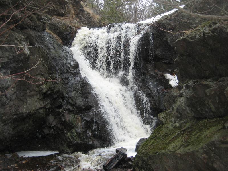
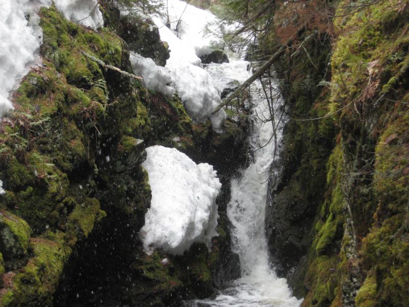
Logan barked mockingly at me from his perch back up on the trail above. Defeated, I set to the task of climbing back up, glancing to my right every couple of yards. Once I got above a bend I finally caught view of the upper drop, an impressive cascade at least thirty feet in height. This, this was a good find, much taller than any of the other drops I had seen along Jacob's Creek. I took a quick picture while clinging onto the steep bank before rejoining Logan.

Zoom in on the towering falls
Still hoping to get closer to this tall and noisy drop we cut off the trail a short distance upstream and meandered back down some of the slope. We didn't find a way to the base, though. All we found was some odd soft grass and a partially blocked view down over the top of the cascade. A better view of this waterfall would have to wait for warmer months.
Back on the path we continued south, passing by some rapids and walking through some pines. A few minutes above the large falls and we entered a small clearing ringed with covered firewood. There were no signs or cabin, just a clearing and several stacks of wood. My guess was a hunting camp, with the owners either bringing a camper or tent several times a year to relax next to the creek.
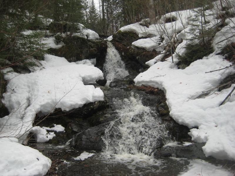
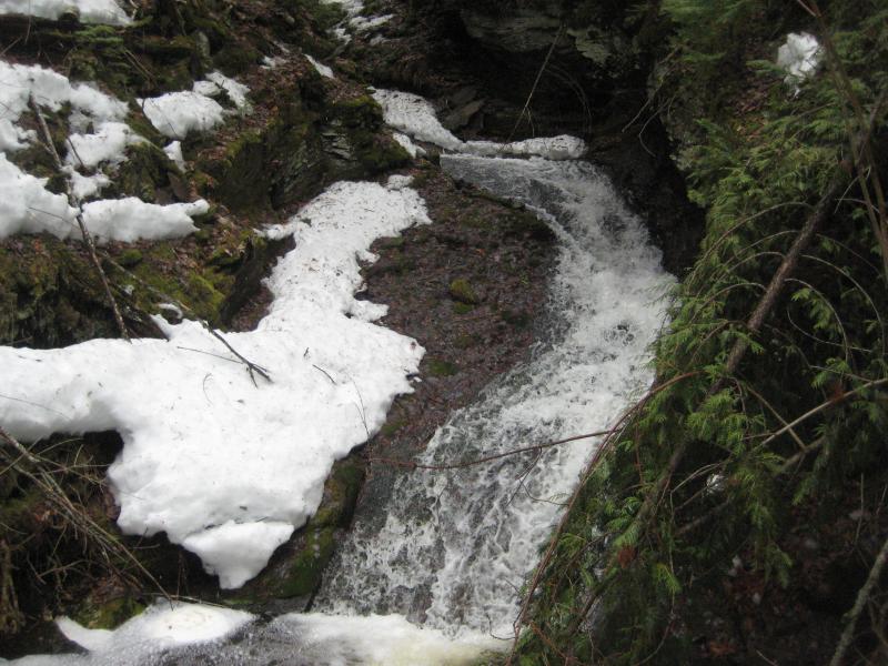
Signs of mining began to show up beyond the camp, cleared land and poor rock. I didn't see any foundations, though I'm not sure if there are any to find at Arnold Mine. There was a small waterfall here, one that I called Arnold Mine Falls, in honor of the poor rock that was spilling into the creek nearby. There was also some half-buried trails in the rock. Someone was trying to turn this into a scenic walkway.

Bubbling, foaming drop

Snow covered paths on the poor rock
It was time to leave Jacob's Creek. I could have followed it another few hundred feet to the cutoff road, though there was nothing left to find that would rival that impressive drop from earlier. Instead I veered east with an access road, tromping over slush and mud, until I reached the plowed Eagle Harbor Cutoff Road.
I hadn't expected this road to be plowed. I probably should have, as there are several year-round residences along it, but I had assumed that it was too far out of the way for the commission to worry about. This would make things much easier. I leashed Logan and we set down the road. There were no shoulders, just the two lanes, and I wasn't about to let him run free down an isolated and curvy mountain road.
No cars came to bother us on this leg of our hike, though. For a mile and a half we walked on the smooth pavement in silence, listening intently for an engine that never came. Everything was quiet up here on the ridge. I was almost sad when Central Road showed up around a bend. This road was not plowed, had barely any snowmobile tracks on it, and would be a tough route to follow. And it's not like the cutoff road had any traffic on it. We were leaving a perfectly good and empty road for a slushy track that would only take us further up on the ridge. With a sigh I led Logan into the knee-deep stuff.
Our route did get easier once we cut off Central and onto the access road to the upper reaches of Copper Falls Mine. There were even a few open patches of road up by the blue shaft and the clearing beyond. Once we reached the uppermost waterfall I admitted that the long walk had been worth it. The waterfall was flowing good, much more water cascading down the plunge than I had ever seen, and much of the rest of our hike would be following this active stream back down the ridge.
Swollen plunge down into the mine
A few yards below the waterfall and the creekbed was dry. This was weird. I doubled back to the waterfall and looked around. There was a good amount of water coming down, much more than the snow could have swallowed up. Then it clicked. This area is riddled with shafts and adits from the old Copper Falls mine. That clearing above the falls was a collapsed shaft, and last year I had seen a bat disappear in the rocks below the waterfall. With a cautious step I walked backwards from the base of the falls. If there was enough cracks and holes here to swallow up a creek I didn't feel like taking my chances.
So, even though Owl Creek drains Owl Lake, none of the water from the lake actually flows down the creek. Yet I had seen water flowing downstream before, below the cutoff road. There must be enough tributaries further to the north to build the creek's flow back up. Hopeful to find water flowing further down the creek I led Logan down the snowy, empty creekbed.
After a quick detour up and over some poor rock on the eastern bank I found some water flowing again. It was a fraction of the flow on the upper falls, a mere skittering along a slanted slope of solid rock, but it was something. If a creek could reappear after a quarter mile than maybe I'd find some more flowing waterfalls further down.

Dark rock beneath white snow and water
More and more waterfalls showed up along the rocky bed. The ground drops close to two hundred feet from the upper falls and the creek looked to be wasting little time making up the difference. The two most impressive drops were located on either side of the tiny private drive that goes through the old company houses of the mine. The upper one was a sloped drop with multiple little cascades, and below the wooden bridge was a direct plunge that showered over a hard rock formation. I was already finding new waterfalls and I hadn't even crossed back over the cutoff road.
Long slide between snowy rock banks

Narrow bridge over the small creek
Small direct plunge over the rocks
The cement culvert below the road was too short and full for me to attempt going through. I climbed up the steep road bank and, checking the empty road for traffic, quickly scurried across with Logan to the far side. There are a few houses clustered near the creek here, possibly dating back to the mining days, and I was pretty sure the land here was private. If I could keep to the creek bed and make my visit short I shouldn't run into trouble.
The north side of the bluff was just as nasty as I remembered. Thick red pines and clinging brush snagged at my passage. I tried to force my way back down to the creek, hoping that I could keep to the rocky bed and avoid the thicker brush, and was disappointed to see that it had dropped into a steep conglomerate gorge. I could get close to a few sections but wouldn't be able to follow it all the way down the bluff.
Sideways slide around the clunky rocks

Tough going between steep banks
One small stop I made was at the old wooden dam and lower falls that I had found last summer. Back then everything had been sticky-hot, the wood and rocks covered in lush green moss. Today it was cold and covered in snow. It was nice to see a stronger flow today, compared to the barest trickle from last year, and I paused here to munch on a few granola bars and suck on a piece of snow.
The snow that had started a half hour ago was stronger now, thick lake-snow flakes that danced around before sinking into the creek's water. I wasn't worried. The temperatures were warm, warm enough to melt the fluff as it settled, and even if some accumulated I was only a few miles from my car. Or five miles. I wasn't entirely sure. Either way I wasn't terribly worried.
Chute narrowly squeezed
Smooth drops over conglomerate
A few more impressive drops showed up, large and strong enough to rival the uppermost drop way up by Owl Lake, and then I was suddenly spilled out upon a vast sea of stamp sand. It had only taken me about an hour and a half to descend the Keweenaw Ridge. The brush had been thick, and the tight creek bed annoying, yet it hadn't been too terrible. My car was somewhere to the west, way over by the Jampot. I saw something curious to east. I had plenty of time. Logan and I headed east.
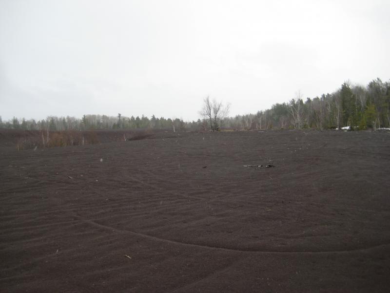
Vast stamp sands stretching below Brockway ridge
Stamp sand stretched far to the north and east, giving me an unfettered look over to a few trees following a winding line. It almost looked like there was a second creek over there, running parallel to Owl Creek. As I neared the trees a huge roar began to filter through from the forest. I turned a corner and saw it - a large white bumbling cascade filtering around trees and dirt.

Swollen waters flowing out of the woods
There were a few oddities that immediately grabbed at my attention. There was much more water here than there had been on Owl Creek, at least three times as much. Also, the water was flowing through a forest, not along a creek bed. This was not an old creek. This had to be something new, something less than a few hundred years. Only one thing made sense: this was where the water emptied out of Copper Falls Mine.
The upper waterfall is not the only place the mine gathers water. During the spring melt there must be plenty of other little creeks and seasonal flows that get channeled through the mine shafts. And the groundwater, too. All this water has to exit the mine somehow, and with it being tunneled into the Keweenaw Ridge it only made sense to have adits down here at the base. I followed the raging waters a few dozen yards upstream and found the source, which confirmed my suspicions. Water bubbled up from a dark sunken hole in the ground.

Flooded forest

Water bubbling up from the ground
Another new waterfall had been discovered, even if it was a bit artificial. Content I turned and headed west with Logan. If my hopes were correct all I would have to do was follow the stamp sands all the way to Jampot. They weren't. A vast swamp showed up a few minutes west of Owl Creek. I circled back, and then tried to follow the creek's flow north in an attempt to walk to M-28. The swamp came with me. There were a few chunks of trees that formed possible bridges through the swamps, all of which were drowned in the deep spring melt. I was trapped on a surprisingly small chunk of stamp sand, one that had once seemed to expansive.

Swamp overtaking the stamp sands
I stopped and reviewed my map. I really thought the sands extended all the way to the north and west. There was east that I could try, though that would just take me to Eagle Harbor and leave me close to five miles of walking along M-28 to my car. I only had one option. I would have to climb back up the bluff and follow it west to Jacob's Falls.
About twenty minutes into the southwest plan and I got a good look down on the swamps below. It was obvious how futile my hopes of sticking to the flat lands had been. Dead trees leaned against one another, grassy sections were flooded, and everyting in between was wide, flat ponds. There was no easy way across that, not during the spring melt. This loop hike had a major flaw on the northern side.

Looking down at the swampy lands below
For a long time I fought against the trademark Keweenaw brush along the sloped ground, trying not to climb too high up the bluff. I didn't want to re-climb the ridge - I just wanted to avoid the swamp below. The brush gave way to logging land, with saplings spring up in close proximity, and I was ducked and weaved sideways to get through the close trunks. Every once in awhile I bumped into what I imagined was a logging track only to have it dead-end and force me back into the young woods.

Stuck high up on Brockway Ridge
When I ran into the deep gorge along Jacob's Creek I was immensely happy. The path took me straight back down the hill and right to my car. Logan and I tumbled in with joy. Six hours of hacking through snow and brush was more than enough for us.
However, there was still more that pulled at me. As I drove south on M-28 I thought back to last year's hike up Gratiot Bluff to Eister Creek. It had been a fun day with Logan, playing around in a narrow conglomerate gorge, though the creek had been barely a trickle. With today's warm temperatures there had to be more than a trickle flowing down the falls. Instead of turning south of 41 I turned north, and soon we were standing at the base of a very soggy trail up Gratiot Bluff.

A wet and cold climb up the bluff
Forcing my legs to climb up the sloppy trail was a painful process. Logan may have been tired as well, though he chose not to show it. He bounced ahead of me impatiently as I slowly climbed behind. I began to look forward to the tricky sections, trail-spanning mud puddles and low drifts, as excuses to stop and plan the best forward route.
On last year's adventure I had climbed up near the top of the falls before descending, and then crawled/slid down along the gorge to each drop. I decided to try the same approach this time. Once the sign showed up I cut off to the right, following what snowshoe tracks I could find, and peered over the to the noisy creek below. The walls were covered in snow and icy and the creek ran tight between snowy banks. There was no way Logan and I could safely descend without a long rope to secure us.

Looking down at the falls
Unwilling to give up I decided to try an alternative approach. Maybe I could get to the base of the falls and climb up the icy rocks. I turned and headed back downhill for a short time before cutting over to the creek. The creek this far down the bluff is rather calm and easy to reach, even if it is brushy, and we reached the lower falls without much problem.

Full creek flowing heavily
There was no way I could climb up that. Even if I ignored the cold water and tackled it directly the rocks would be slick and icy. This was as much of the waterfall as I'd be seeing today. Only partially content we turned and headed back to the car, stopping for a cursory look over the half-thawed Gratiot Lake.

Dreary ice under a dreary sky
Cold, wet, and tired, I drove us back up to 41 and then cut over towards Lac la Belle. There was one last easy stop to do before I could leave today. There was little snow along the sides of the lake and it was easy to find a parking spot at Haven Falls Park. The waterfall itself was a solid sheet of white, much more grand than the usual half-trickle found here.

Swollen plunge over Haven Falls
This was a bittersweet visit. Haven Falls was one of the first waterfalls that I had been to in the Keweenaw, dating all the way back to June of 2008 with Katie and Logan. Now, today I was here with only Logan, and soon we would be moving far away from Houghton. This was our last trip here. I meandered around for a short time, checking out the upper drops and icy bridge, doing my best to delay. Eventually we jumped back in the car and headed down towards Gay.

Last glance back at the waterfall
I had little more than a week left before the move to Wisconsin. There were dozens more waterfalls to visit during the spring flow, and many more dozens that I had hoped to add to the website, so the next few trips would probably be very packed. As I left Haven Falls I considered the Keweenaw done. For now, at least. There was plenty of places to visit in the south, many more spots to check out in Baraga and Marquette Counties. Maybe I'd be back in the Copper Country in the years to come.


Comments (0)